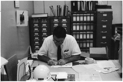
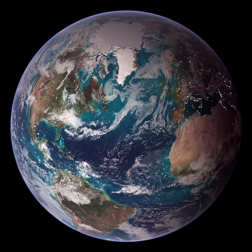
Earthrise over the moon as seen by the astronauts of Apollo 8 on December 22, 1968.

This iconic image has become my regular Earth Day illustration. It was not the first image of the isolated Earth from space. It was the first which contrasted in the same image the wet, blue and green, atmospheric Earth with the barren, dusted, lifeless Moon.
It is easy to deceive ourselves that we can exploit the Earth and dehumanize others – basically, sh*t where we eat and sleep – without consequences. It is hard to see, concretely and measurably, how interconnected and interdependent we are.
Images like those above remind us that we are alone, isolated, and fragile. We are stewards of the Earth. We are gardeners of the world. It’s our responsibility now.
The rising Earth is about five degrees above the lunar horizon in this telephoto view taken from the Apollo 8 spacecraft near 110 degrees east longitude. The horizon, about 570 kilometers (250 statute miles) from the spacecraft, is near the eastern limb of the Moon as viewed from the Earth. On the earth, the sunset terminator crosses Africa. The south pole is in the white area near the left end of the terminator. North and South America are under the clouds. The lunar surface probably has less pronounced color than indicated by this print.
Despite the origin of the photo at the top of this post, I am opposed to the human “exploration” of space at this stage in the development of our species and civilization. (Reporter: “What do you think of Western civilization?” Gandhi: “I think it would be a good idea.”) We know all we need which can be learned from sending and keeping humans in space, other than hot to keep humans in space. That should not be our priority. It is far too costly, in economic, human, and environmental costs, for the benefits. We have far more pressing and urgent investments to make, in education, health, and our increasing hunger for things.
[goog.gl]
Related Content
Apollo: a personal/biographical perspective, 2009-07-19
Happy Earth Day, 2009-04-22
Happy Earth Day!, 2008-04-21
We Are All One World, 2007-10-10
Links
Wikipedia: Earth Day
Apollo, NASA