Spring Cleaning on Cortelyou Road

The daffodils are pushing up along Cortelyou Road and they would be so much prettier if they don’t bloom in the midst of garbage! Join Sustainable Flatbush and your neighbors from the Beverley Square West Association to help clean up the tree beds.

When: Sunday, March 21st
Where: Meet up at 10am in front of the Library, near the Greenmarket tent, at the corner of Argyle and Cortelyou Roads.
If you miss the meet-up, look for us along Cortelyou Road between Coney Island Avenue and East 16th Street.

Bring gloves and rakes if you have them; we will also have some to share. Children are welcome to join us!

Cortelyou Daffodils

Saturday, October 24: Meet the Trees

Fraxinus americana, White Ash, one of the street trees that will be on the tour.
Fraxinus americana, White Ash, 1216 Beverly Road

On Saturday, October 24, Sustainable Flatbush will host its first Fall Street Tree Walking Tour. And I’m looking forward to once again be one of the guides for the tour.


FOR IMMEDIATE RELEASE

Brooklyn, NY October 16, 2009

SUSTAINABLE FLATBUSH FALL 2009 STREET TREE WALKING TOUR
Saturday, October 24, 2009—Rain or Shine

Based on the success of the annual walking tour events in celebration of Arbor Day and spring in bloom, Sustainable Flatbush is now introducing the inaugural Fall Street Tree Walking Tour. The tour guides will be Tracey Hohman, professional gardener, and Chris Kreussling, aka Flatbush Gardener, both neighborhood residents.


Sustainable Flatbush Street Tree Walking Tour, Arbor Day 2009. That’s me in the middle, next to the tree. Photo by Keka

Throughout the tour, your street tree guide will:

  • identify trees and their characteristics
  • share interesting facts
  • explore local tree history
  • discuss the many ways street trees benefit the environment
  • explain how to obtain and care for street trees
  • and much more!

This free event is a perfect opportunity to visit Victorian Flatbush in the heart of Brooklyn and experience the neighborhood’s breathtaking street trees—including some that are more than 100 years old!

Location:
Tours start at Sacred Vibes Apothecary, 376 Argyle Road, just south of Cortelyou Road


View Sustainable Flatbush Fall 2009 Street Tree Walking Tour in a larger map

Directions:

  • Take the Q train to Cortelyou Road Station and walk west after exiting the station toward Argyle Road.
  • Buses that stop on or near Cortelyou Road include the B23, B103, B68, and BM1,2,3,4 and x29 express busess.
  • As a reminder, check the MTA website for schedule and service advisories before you head out.

Time:
Tours depart at 11:00 AM and 12:00 NOON.
Tours take about 2 hours to complete and are 1 mile in length.
This is a rain or shine event – please dress for the weather!

For more information, please contact Sustainable Flatbush


Foliage Report

The New York State Fall Foliage Report for the week of October 14-20 is reporting that NYC is “just changing.”

FoliageMap 20091016

I can confirm that, with Dogwoods, White Ash and now Locust trees all in full color. Sweet Gum and Oaks are starting to turn. If cooler weather persists through the week, peak colors will probably arrive just in time for Halloween on the 31st. Still, there should be lots of color for us to enjoy on the 24th.

A Japanese Maple on Marlborough Rad in Prospect Park South, part of the tour, November 2007
196 Marlborough Road, Prospect Park South

[bit.ly]

Related Content

Fall Approaches, 2009-09-26

Links

Fall Foliage Walking Tour October 24th!, Sustainable Flatbush

Plant Trees in Ditmas Park West, Sunday, 4/26

I helped plant this Zelkova serrata, Japanese Zelkova, last year.
Tamping in

Part of the Arbor Day weekend activities in Flatbush, on Sunday you can help plant 9 trees in Ditmas Park West, one of the neighborhoods of Victorian Flatbush.

Meet at 10am at 458 Rugby Road [GMAP]. Bring your own tools and gloves, if you have them. Wear sturdy work boots, and prepare to get dirty! No rain is predicated through the weekend, so you won’t have to deal with last year’s mud. Possibly record highs – temperatures in the upper 80s – are predicted for Sunday, so wear your sunscreen and bring lots of water to stay hydrated.

At the meeting place, they will form work crews which will fan out to different locations. Some will plant trees, some will do cleanups. At 1pm, folks meet up for lunch.

[bit.ly] [TinyURL]

Related Content

2008 Ditmas Park West Tree Planting

Flatbush Tree Tour, Saturday, April 25

2009.04.23 IMPORTANT TRANSIT SERVICE ADVISORY: The Manhattan-bound Q train will only stop at Church Avenue between Kings Highway and Prospect Park this weekend. Coney Island bound trains will make all stops.


Argyle Road in my neighborhood of Beverley Square West in Flatbush, Brooklyn, one of the blocks that will be on Saturday’s tour.
364 (left), 358, and 352 Argyle Road, Beverley Square West

This Saturday, April 25, join Sustainable Flatbush in our second year of celebrating Arbor Day and the magnificent street trees of Brooklyn’s Victorian Flatbush. The Sustainable Flatbush Arbor Day 2009 Street Tree Walking Tour reprises last year’s route, visiting the Victorian Flatbush neighborhoods of Beverley Square West and Prospect Park South.

Tours will depart at 11am and 12noon from Third Root Community Health Center at 380 Marlborough Road, just south of Cortelyou Road. [GMAP] Take the Q train to Cortelyou Road and walk one block west (left) to Marlborough Road after exiting the station.


View Sustainable Flatbush Arbor Day 2009 Street Tree Walking Tour in a larger map

Your tour guides will be my neighbor, Tracey Hohman, a professional gardener, and yours truly. Throughout the tour, we will:

  • identify trees and their characteristics
  • share interesting facts
  • explore local tree history
  • discuss the many ways street trees benefit the environment
  • explain how to obtain and care for street trees
  • and more

This FREE tour is a little over a mile in length and lasts approximately 90 minutes. Tours will take place rain or shine. Please gear appropriately for the weather and walk: sunscreen, comfortable walking shoes, water, and so on.

The area boasts a rich variety of both street trees and ornamental trees and shrubs. On the tour, you will see:

  • Acer platanoides, Norway Maple
  • Aesculus hippocastanum, Horsechestnut
  • Amelancier, Serviceberry
  • Betula nigra, River Birch
  • Cercis canadensis, Redbud
  • Cornus florida, Flowering Dogwood
  • Cryptomeria japonica, Japanese Red Cedar
  • Ginkgo biloba, Ginkgo
  • Gleditsia triacanthos, Honey Locust
  • Liquidambar styraciflua, Sweetgum
  • Metasequoia glyptostroboides, Dawn Redwood
  • Pinus strobus, White Pine
  • Platanus x acerifolia, London Plane
  • Pyrus calleryana, Flowering Pear, Callery Pear
  • Quercus palustris, Pin Oak
  • Quercus robur ‘Fastigiata’, Columnar English Oak
  • Sophora japonica, Japanese Pagoda Tree, Scholar Tree
  • Tsuga canadensis, Eastern Hemlock
  • Ulmus americana, American Elm
  • … and many more

For more information about the tour, please email garden AT sustainableflatbush DOT org.

Sustainable Flatbush brings neighbors together to discuss, educate, and advocate for sustainable living in our Brooklyn neighborhood and beyond.

[bit.ly]

Related Content

Arbor Day posts

Links

Sustainable Flatbush

Resources

Web

To request a free street tree, fill out the form at http://www.nyc.gov/freetree

Million Trees NYC
Trees New York

Online Tree ID Guide, Arbor Day Foundation

Books

Dirr, Michael A. Dirr’s Hardy Trees and Shrubs: An Illustrated Encyclopedia. Timber Press. ISBN-13: 9780881924046

Happy Holidays

The MTA thwarted our plans to attend a concert of a women’s choir this evening. So Blog Widow and I turned back and walked around our neighborhood, taking in the snow-beings and holiday lights.

Enjoy this slideshow of my Flickr set of photos from the evening. For best viewing, click the play button, then click the icon with four arrows in the lower-right to view it full-screen on a black background.

Related Content

Flickr set

Cortelyou Road Park, Park(ing) Day NYC 2008

Cortelyou Road Park, Park(ing) Day 2008
Cortelyou Road Park, Park(ing)Day NYC 2008

For the second year, Sustainable Flatbush created Cortelyou Road Park, a mini-park-for-the-day on Cortelyou Road in Flatbush that was one of 50 such sites across New York City.

For our park, I loaned furniture and container plants from my garden to recreate a garden room on Cortelyou Road. The grass was sod donated by Transportation Alternatives (T.A.). The Flatbush Food Co-op donated a gift basket to be raffled off, and kept us stocked in popcorn and chips. Vox Pop donated urns of coffee.

Setting up
Setting up
Setting up

Cortelyou Road Park, Park(ing)Day NYC 2008

JUMP!
JUMP!

Finger painting
Finger Painting
Finger Paints

Drawing
Drawing

Bounty donated by the Flatbush Food Coop

[bit.ly]

Related Content

Flickr photo set

Links

Park(ing) Day 2008, Sustainable Flatbush
Flatbush Food Co-op
Vox Pop

Park(ing) Day NYC
Park(ing) Day
Eyebeam
Transportation Alternatives (T.A.)
The Open Planning Project (TOPP)
The Trust for Public Land
Cortelyou Branch, Brooklyn Public Library, 1305 Cortelyou Rd. at Argyle Road

Visit Cortelyou Road Park on Park(ing) Day, Friday, September 19

Cortelyou Road Park, Park(ing) Day 2007. Photo: Keka Marzagão
Park(ing) Day 2007 : Cortelyou Rd. Park, Brooklyn!

On Friday, September 19th, Sustainable Flatbush will transform a parking spot on Cortelyou Road in the Flatbush neighborhood of Brooklyn into a park, complete with grass, plants, and seating. “Cortelyou Road Park”, located on the corner of Cortelyou and Argyle Roads [GMAP], is one of 50 sites around New York City – twice as many as last year – participating in Park(ing) Day, an international event.

“Park(ing) Day is an opportunity to create a community gathering space, and to make a statement about how we allocate public space,” says Anne Pope, Founder/Director of Sustainable Flatbush. “In this neighborhood, despite all the beautiful homes and lawns and gardens, the amount of public green space per person is much lower than the city average.”

Cortelyou Road Park will be open from 9AM to dusk and include activities for children and adults – a school and several day care centers are located nearby – and an art exhibition in the adjacent plaza of the local Brooklyn Public Library branch. “Using 160 square feet of concrete for temporary storage of an automobile benefits only its owner. If we can take that area and transform it into something magical that is enjoyed by dozens of people, maybe that’s a better use of the space,” says Pope. “I hope it gets people thinking about how public space can be allocated for the maximum benefit.”

This year, park builders are putting new emphasis on site-specific designs that will reflect the social, cultural, and architectural contexts in which they’re situated. This approach will also generate innovative proof-of-concept designs for permanent public space reclamation. Seating areas, art installations, and community engagement will all make the case for a more sensible and human-friendly distribution of available urban public space.

Also new is Park(ing) Day Redux, taking place on October 18th. This capstone exhibit will feature a rebuild of selected parking spots on a closed street in front of Eyebeam Art and Technology Center on West 21st Street, photos and media from the September event, and a mixer with the city’s most imaginative public space interventionists.

Sustainable Flatbush brings neighbors together to discuss, educate, and advocate for sustainable living in our Brooklyn neighborhood and beyond. Their vision of a sustainable neighborhood includes equal access to healthy food and open spaces; preserving affordable housing (and the diverse population it enables) through innovative energy practices; and high-quality, resource-efficient transportation options (including cycling). As residents of one of the most culturally diverse neighborhoods in the nation, they strive to learn from each other and emulate global best practices in sustainability, whether that translates into cutting-edge technology or just living more simply.

Links

Sustainable Flatbush
Park(ing) Day NYC
Park(ing) Day
Eyebeam
Transportation Alternatives (T.A.)
The Open Planning Project (TOPP)
The Trust for Public Land
Cortelyou Branch, Brooklyn Public Library, 1305 Cortelyou Rd. at Argyle Road

Upcoming local events

It’s a busy season for tours and such. Here is a highly selective (ie: things I would go to, if I have the time and/or my schedule permits) list of (mostly) local events. Details for all these as I know them are in my Google Calendar in the sidebar.

  • Wednesday, May 21, 6pm, Prospect Park Audubon Center: Bee Watchers 2008 Orientation
  • Thursday, May 22, 3pm: Cortelyou Road Streetscape Project Ribbon Cutting & Opening Ceremony
  • Sunday, June 1, 12noon: Prospect Lefferts Gardens House Tour
  • Saturday, June 7 and Sunday, June 8: The 1st Annual Flatbush Artists Studio Tour (FAST)
  • Sunday, June 8, 11am: Brownstone Brooklyn Garden Walk (not Flatbush, but not to be missed if you’re interested in urban gardens and gardening)
  • Sunday, June 8, 1pm: Victorian Flatbush House Tour
  • Thursday, June 12, 7pm: City Planning Commission presents proposed zoning changes for Victorian Flatbush (northern half of CB14)
  • Saturday, June 21, 11am: Newkirk Avenue Block Party

I am always on the lookout for opportunities to visit and promote gardens in Brooklyn. If you are organizing or know of any garden walks or tours in Brooklyn and would like me to publicize it, please email me the details. My email address is in my profile, available in the sidebar.

Forgotten Flatbush: The Albemarle Road Pedestrian Bridge

In the first Imagine Flatbush 2030 workshop, we enumerated “Assets” and “Challenges”. At our table – and it sounded like the experience was shared at others’ – where someone lived emerged as a primary determinant of what appeared in which category. Sometimes shared concerns, such as transportation, appeared as both an asset and a challenge, depending on where one lived. It became clear to me that the lines can be sharply drawn, sometimes block-by-block.

I’m a newcomer to the area, having moved here only in Spring of 2005. I researched more and more about the area and its history as we committed to buying a home and moving here. I’ve still only visited a small portion of Flatbush. IF2030 is making me curious about exploring more of it.

Part of what I want to explore more of is literally “on the other side of the tracks” from where I make my home. The B/Q subway line runs through this neighborhood as an open trench. There are several places where there is no crossing, and the cut forms a geographical barrier, a steel river, separating one side from the other. It wasn’t always so. With homage to Forgotten NY, here’s a little piece of Flatbush that’s not quite forgotten, still part of living memory, the Albemarle Road pedestrian bridge.

Google Map of the location of the old Albemarle Road pedestrian bridge. 143 Buckingham Road is also highlighted; it’s a landmark in all the historical photos of this crossing. The markers show where I took the photos for this article.

View Larger Map

The BMT as I remember — never rode it much, but had relatives on East 17th & Beverley Road. We would always go to the Albemarle Road footbridge by the tennis courts over the BMT cut, and watch the trains.
– Steve Hoskins, SubTalk Post #93389, NYC Subway

Eastern Dead End of Albemarle Road at Buckingham Road. 143 Buckingham Road is at the left of the photograph.
Dead End, Albemarle Road at Buckingham Road

Western foundation of Albemarle Road Pedestrian Bridge

“I seem to have a memory – or is it just a dream? – going back to my earliest childhood, associated with a place about a mile in a different direction from where I lived, towards Prospect Park: it is a stretch of about five blocks of Albemarle Road, going from the Brighton subway underpass to Coney Island Avenue. One got there from our side of the subway tracks by crossing over on a small footbridge. On the far end of the bridge, Albemarle Road suddenly widens, and in the middle of it there is a traffic island, covered with trees and extending a 11 the way to Coney Island Avenue; there are also trees on both sides of the street. My first encounters with this scene are in my memory entirely intermingled with my dreams of it, a recurring vision of overwhelming loveliness at the edge of things, beyond which something entirely new and different must lie.”
– Ronald Sanders, A Brooklyn Memoir, via Living in Victorian Flatbush

Western Dead End of Albemarle Road near East 17th Street. 143 Buckingham Road is at the right of the photograph, across the tracks.
Western Dead End, Albemarle Road, near East 17th Street

East Foundation of Albemarle Road Pedestrian Bridge. 143 Buckingham Road is in the center, across the tracks.
East Foundation of Albemarle Road Pedestrian Bridge

Albemarle Road is interrupted by the subway cut for the B/Q lines. In the late 19th Century, several rail lines were developed to take passengers from the City of Brooklyn, what we now think of as downtown Brooklyn, through the other villages and towns such as Flatbush, to the beach resorts on Coney Island and Brighton Beach. By the 1870s the Brooklyn Coney Island Railroad ran along Coney Island Avenue. By the 1890s, the Brooklyn, Flatbush and Coney Island Railroad (BF&CI) ran along what is now the current route of the B/Q subway line. Most of Flatbush was still farmland at the time. When the Flatbush farms were sold and the area was developed at the turn of the 20th Century, the tracks still ran at grade.

In this 1873 map of Flatbush, Prospect Park and the Parade Grounds are already laid out to the north, and the Brooklyn Coney Island Railroad runs along Coney Island Avenue. On this map, Parkside Avenue is named Franklin Avenue, Church Avenue is named Church Lane, and Cortelyou Road is named Turner Harrow (or Narrow?) Lane. The Waverly Avenue shown on this map no longer exists; it’s later replaced by Albemarle and Beverly Roads Road, whose future locations are shown, but neither named nor yet built. The future route of the B/Q line is not shown. The families whose landholdings and houses appear on this map lent their names to several streets and neighborhoods: Turner, Hinkley, Ditmas and Vanderveer.
Map of Flatbush, Brooklyn, 1873

In an 1888 USGS Survey Map of Brooklyn, just a small portion of which is shown here, Waverly Avenue has been “de-mapped.” The roads built in its place, unnamed on this map, are Avenues B and C; these will be renamed later to Beverly and Cortelyou Roads. Between them run East 11th through East 14th Streets; in the early 1900s, these will be renamed to Stratford, Westminster, Argyle and Rugby Roads to cash in on the cachet of Prospect Park South. The BF&CI, which began service in July 1878, is also now in place. East of that, the eastern half of Avenue A (Albemarle Road) has been built, along with East 17th through 19th Streets.
Detail, 1888 USGS Survey Map of Brooklyn

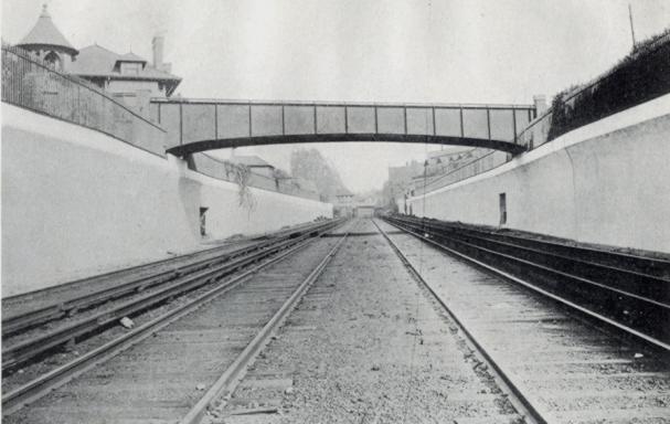
Through the early 1900s, all these railroad lines ran at grade, at street level. There were also trolley lines, at first horse-drawn, then later electrified, on many of the crossing streets. Development brought a burgeoning residential population, more traffic, and more traffic conflicts and accidents. The decision was made to separate the rail and street traffic by moving them to different levels, passing above and below each other.

This photo from the 1918 “Reports of the Brooklyn Grade Crossing Elimination Commission” shows the Albemarle Road Footbridge. The line has been widened to four tracks and now runs below grade. Today, the local Q train runs on the outer tracks, while the express B runs on the inner tracks. 143 Buckingham Road is visible on the upper left of the photograph. Thanks to Art Huneke for permission to use this photograph. This photo appears on his page Brighton Beach Line, Part 3.
Albemarle Road Footbridge

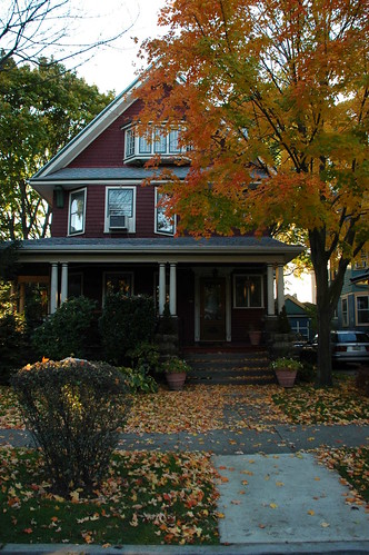
The physical contrasts could hardly be stronger across the tracks: a wide, tree-lined boulevard with large, detached wood-frame houses on one side, and tall, multiple-unit residential buildings with few trees on the other. It is tempting to imagine what it would be like to restore the pedestrian bridge, eliminating at least a geographical barrier between these two halves of the same neighborhood. Would it help us to make other connections, to recognize our common assets and challenges, and work together to create a future we can all live with?

Related posts

Imagine Flatbush 2030

Links

My Flickr photo set
Brighton Line, NYC Subway
ARRT’s Archives, Art Huneke’s Web site
Rapid Transit Net
The Brooklyn Grade Crossing Elimination Project, 1903-1918