As Edward Luciano began a run as motorman on the Brooklyn Rapid Transit’s (BRT) Brighton Beach line on the evening of November 1, 1918, getting home quickly and safely might well have been foremost in his mind. Luciano’s career as a motorman had started earlier that very day, when the BRT pressed the twenty-three year-old dispatcher into service after company motormen went out on strike. Weakened by a recent bout with influenza and emotionally anguished by the death of one of his children from flu the week before, Luciano nonetheless complied with his employer’s wishes.
…
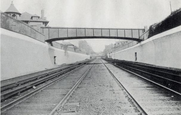
The posted speed for the tunnel entrance was six miles per hour; witnesses estimated that Luciano’s train entered the curve at over thirty. The train’s first car hung precariously to the track, then derailed upon entering the tunnel. The second car slammed violently into a concrete abutment, losing its roof and one of its sides in the impact. The third car disintegrated into a tangled mass of wood and glass.
– Death Beneath the Streets, New York Underground, The American Experience, PBS

The Malbone Street train sits in the BRT’s 36th St. Yard after salvage. The relatively minor damage to 726 [the first car in the photo] shows why most in the first car escaped serious injury. Even the window of Motorman Luciano’s cab (left, front) is intact. Not so lucky were those in trailer car 80 immediately behind, with half the car sheared away. Behind 80 is motor car 725, also almost unscathed. Chillingly absent between 80 and 725 would have been car 100, the remains of which were dismantled at the scene.
Dozens of passengers died immediately, many of them decapitated or impaled by shards of wood and glass. Others were electrocuted by the third rail, which had shut down on derailment but was turned back on by offsite monitors who attributed the shutdown to labor sabotage. [Note: The claim of death by electrocution is refuted in Cudahy’s book.] Rescuers rushed to the station, to help the dazed and injured and to carry away the dead. The power failure in the tunnel posed a problem for rescuers that was partially solved when automobiles pulled up near the entrance to the station to illuminate the ghastly scene.
Worried friends and relatives came from across the city and waited outside the station for news of loved ones who frequented the Brighton Beach trains. Medical personnel used the Brooklyn Dodger’s Ebbets Field as a first aid station. And Mayor John Hylan, a strong opponent of privately operated transit lines like the BRT, arrived on the scene with freshly-milled accusations of transit-interest malfeasance.
– Death Beneath the Streets
- ALEXANDER, James, 647 Fenimore Street
- ALFARO, Peschal, 160 Robinson Street [I can’t locate this street on current maps of Brooklyn. Has this been renamed to Parkside Avenue?]
- AMREIN, Ada, Address unkown
- ARENA, Mabel, 186 Lefferts Avenue
- BARCINO, Eugene Edward, 42 Henry Street, Flatbush [sic, this address is in Brooklyn Heights, not Flatbush]
- BARGIN, Etta, 1145 East 14th Street
- Bechtold, Emily or Elise M., 362 East 9th Street
- BERKOWITZ, Herman, Address unknown
- Borden, Helen, 445 Riverside Drive, Manhattan, or 1011 Ocean Avenue [two addresses were given for Ms. Borden]
- Bogen, David, 27 years old, 94 Kenmore Place [Originally listed among the dead as D. Borgen of 97 Kenmore Place]
- Brunswick, David, 70 years old, 847 East 10th Street
- BURTON, Mary, 1458 East 17th Street
- Calibria or Calabria, Rose, 1935 East 9th Street [Published in NY Times, 2008-09-06, five days after the accident]
- CLEARY, Margaret, 318 Parkville Avenue
- Clifford, Ethel or Louise, 485 Argyle Road
- COADY, Emily, 682 Argyle Beach [sic: Argyle Road]
- Condra, Louisa G, 23 years old, Brooklyn [No address given. Not listed originally among the dead or injured. “Louisa G. CONDRA, also killed, was born in Newark twenty-three years ago and had been a resident of Brooklyn for three years. She was secretary to the vice-president of the National City Bank in Manhattan and is survived by her mother, Marguerite, and two sisters The funeral will be held to-morrow morning with a requiem mass at the Church of the Immaculate Heart of Mary. Interment will be at Newark.”]
- COOPER, Margaret, Detroit, Mich.
- ENGGRAN, John W., 37 East 10th Street
- FLEMING, Catherine, 7 East 10th Street
- FITZPATRICK, Ed., Avenue H and East 17th Street
- FLAHAVE, James F., 277 East 38th Street
- Gardner (or Gardiner), Marion (Mary) Norcross, 347 Lincoln Road
- GILBERT, Michael, 26 years old, 1510 East 18th Street or 1819 East 13th Street [two addresses were given for Mr. Gilbert]
- GILFEATHER, Thomas F. 388 East 49th Street
- GILLEN, Harry P., 29 years old, 1539 East 13th Street or 1634 East 13th Street [two addresses were given for Mr. Gillen]
- GIVNAN, Thomas, 28 years old, 1601 Voorhies avenue
- GUIDE, Nicholas, 1505 Neck Road
- Hennison, Emelia, 95 Lenox Road [Listed only in association with Aline Schwaan at the same address]
- HOLMES, George W., 611 Westminster Road
- HOLTORF, Theodore, 60 years old, 984 East 18th Street
- HOPKINS, Lewis, 2130 Bedford Avenue
- JACKOWITZ, Sophie, 4301 Church Avenue
- JOHNSON, Mary, Address unknown
- KEMPF, Christina, 203 Parkside avenue
- KERR, David B. 132 Nassau Street, Manhattan
- KINSIE, Benjamin A., 79 Haven Avenue, Manhattan
- KIRCHOFF, Clara, 877 East Fifteenth Street
- LARSEN, H.W., 713 Avenue N
- LAWREY, Nellie, 1782 Shore Road
- LAWSON, T. C., 1716 Caton Avenue
- LEE, Fred W. 212 South Oxford Street
- LOMBACK, Harry 22721 77th Street [invalid street address]
- LOMBARD, Henry, 1016 East 18th Street or 1919 East 18th Street [two different addresses were given for Mr. Lombard, in the initial list of the dead, and in a follow-up mention]
- LOURING, Frank J., 1025 East 15th Street
- LOVE, Bessie, 90 St. Marks Place
- LOVELL, Aubrey, 1522 East 10th Street
- LYONS, Caroline, 1616 Avenue H
- MAIER, Joseph A. 204 Midwood Street
- MALAMAUD, Abraham, 602 East 16th
- MALONEY, Lillian, 178 Lefferts Avenue
- MATTOOK, Ethel, 335 East 21st Street
- MEEHAN, Helen, 22, 348 Eastern Parkway
- METZGER, Ira H., 816 East 14th Street
- McMILLEN, Carnette, Address unknown
- McCORMACK, Mrs. Grace, 1404 Cortelyou Road
- MUNN, Sadie, 25 Rugby road
- MURPHY, Grace, a school teacher, 1297 Homecrest Avenue [invalid address]
- NAGLE, Richard, 2124 East 24th Avenue
- PALMEDO, Alexander M., 439 East 19th Street
- Payne, Raymond, 18 years old, 1213 Avenue H
- Pierce, Wilbur F., 23 years old, 244 Lefferts Avenue
- PILKINGTON, Mrs. 214 Webster Avenue
- PORTER, Willis D., 721 Argyle Road [Mistakenly reported as dead, as “William Porter, Argyle Road”]
- PORTER, Edward Erskine, 309 Caton Avenue [Possibly 307 Caton Avenue?]
- PROUT, Grover T., 275 Ocean Avenue
- Rathe, John Charles Ferdinand (or Roth, Charles), 311 E 19th St
- RUBIN, M. H., 675 Flatbush Avenue
- RUSSO, Mamie, 485 Grand Avenue
- RYAN, Michael, 36 years old, 2163 Nostrand Avenue [Possibly 2162 Nostrand?]
- SCHWAAN, Aline, 95 Lenox Road
- SCUDDER, Ethel, 1221 Avenue Q
- SHEVIT, Syd, 224 East 26th Street
- SHIEDEN, John, 420 Cortelyou Road
- STEVENS, W. E., 150 Nassau Street, Manhattan
- SCHAEFER, Harold, 2804 Farragut Road
- Stephens, W. A., 83 Rugby Road
- STERN, Adolph, 141 Central Avenue
- SULLIVAN, Margaret, 19, 2745 Bedford Avenue
- TEN BROUCK (or Broeck), Floyd, 46 years old, 1419 Avenue G (Glenwood Road, today)
- THORN, C.C. 2023 Caton Avenue
- TIETJEN, Johann W., 420 Cortelyou Road
- TOLZE, Genaro, 2439 East 14th Street
- TOWNSON, T.G., 1716 Caton Avenue
- VINCENZO, Louis A. 493 Gravesend Avenue [Published in the NY Times, 2008-09-06, five days after the accident. I can’t locate this street. Is this know today as Gravesend Neck Road?)
- VINEBERG, Morris, 1706 Bath Avenue
- WALKER, Marion, 1670 East 10th Street
- WEED, H.E., Address unknown
- WATTS, Hazel, 48 East 22nd Street
- WALSH, Genevieve, 4301 Church Avenue
- WOELFER, Charlotte, 738 East 21st Street
Injured
AYER, Oscar, 600 East 16th Street
AMREIN, Kurt, 634 West 135th Street, Manhattan
ANTONELLO, Rosario, 1419 Lincoln Road
BAIRD, Loraine, 2542 East 5th Street
BANELSON, Vera, 170 Coleridge Street
BARRETT, Susan, 1550 East 12th Street
BOOM, Martin P., 635 Flatbush Avenue
BRAULT Zephrin, 107 Martense Street
BROSER, Mrs. Wm., 2641 East 21st Street
CALABRIA, Rose, 1935 East 9th Street [or Calibria, she died 4 days later]
Castellani, Marie, 2764 Haring Street, Sheepshead Bay
CLEARY, Mary, 318 Parkville Avenue
CLINCHY, Susan, 1704 Kings Highway
CORCOCILLO, Joseph, 1089 East 39th Street
COSTELAN, Marie, 24 Harrett Street
DRENNAN, Margaret, 1911 Homecrest Avenue
(No. listings for “E”)
F.
FELICIA, Samuel, 38 Darby Street
FENNON, Edith, 826 Avenue P
Fitzpatrick, Edward N. [No address available. Mr. Fitzpatrick was not originally listed among the injured. He was awarded $35,000 in 1920 from injuries received in the crash. Reference: New York Times, 1920-01-08]
FUCHS, Pauline, 2902 West 17th Street
FULLER, Elizabeth, 364 East 18th Street
G.
GOWARD, Harold, 234 Lefferts Avenue
GIILERDI, Sylvia, 2617 Jerome Avenue
GUTHRIE, James, 800 East 15th Street
H.
HARLEY, Helen, Crown Street
HARRIS, Leonore, 62 Marlboro Road
HARRIS, Gertrude, 810 Avenue U
HARM, George, 2801 East 7th Street
HAYES, Nora, 287 East 17th Street
HALL, Martha, 2715 East 23d Street
(No listings for “I”)
J.
JUDD, Francis, Manhattan Beach
(No listings for “K”)
L.
LARSON, Lillian, 713 Avenue M
LEE, Henry A. 971 Utica Avenue
LERNER, Nathan, 15 President Street
LEES, Loretta, 619 East 4th Street
LEES, Mary, 619 East 4th Street
M.
MITCHELL, Matilda, 3456 East 15th Street
MURPHY, Veronica, 1922 Homecrest Avenue
McGARRY, John, 120 Avenue C
MANDER, Walter, 840 Flatbush Avenue
MARTENSE, Gary, 1501 Avenue U
MULE, Ernest, 2421 East 18th Street
MUSSON, Silas, 402 Ocean Avenue
MELLOW, William, 568 East 18th Street
MESSIER, Josephine, 2163 Coney Island Avenue
(No listings for “N” and “O”)
P.
PIERCE, Mrs. Kate, 1011 Ocean Avenue
PITTS, Frank G. 632 East 16th Street
POCHICHIE, Louis, 354 Prospect Place
(No listings for “Q”)
R.
ROCHES, Mary, 2647 East 18th Street
REILLY, Alfred, 153 Martense Street
S.
SCHMITT, Geo. W., 856 Est 5th Street
SEYMANN, Harry, 104 Woodruff Avenue
SCHUBERT, Arthur, 100 Webster Avenue
STOBEI, Rev. Joseph, 225 Emmons Avenue
SULLIVAN, Loretta, 437 East 15th Street
(No listings for “T” and “U”)
V.
VAN ARSDALE, Betty, 3122 Mermaid Avenue
[bit.ly]
Related content
Malbone Street Wreck, Google Map
Links
Malbone Street Wreck, Wikipedia
Death Beneath the Streets, New York Underground, The American Experience, PBS
The Malbone Street Wreck, by Brian Cudahy [I’ve got this back-ordered from Amazon]
Review of the book by Paul Matus on rapidtransit.net
Franklin Shuttle, Kevin Walsh, Forgotten New York
BMT Franklin Avenue Line, Wikipedia
Lanes of Mid-Brooklyn, Kevin Walsh, Forgotten New York
Eve of Destruction, 1918: The Malbone Street Horror and Day of the Dead, A Year in the Park
Malbone Street Wreck, nycsubway.org, transcription of the article published in the New York Times on November 2nd, 1918
List of dead and injured, Brooklyn Standard Union
Alternative Map